
Satellite Image Ground Truthing — J&K and Ladakh
Government / Geospatial · Entire Jammu & Kashmir including Ladakh
Published · Updated
Project Overview
Bearing Technology Private Limited (BTPL) carried out statewide DGPS ground truthing of satellite imagery across Jammu & Kashmir including Ladakh, for the Flood Control Department, J&K, through Suhora Technologies Pvt Ltd, delivering an independently observed ground reference dataset.
BTPL carried out satellite image ground truthing across the entire Jammu & Kashmir region, including Ladakh, for the Flood Control Department, J&K, working through Suhora Technologies Pvt Ltd. The assignment established DGPS-observed ground reference against which satellite-derived mapping and image interpretation could be validated. Field teams visited distributed sample locations spanning valley, hill and high-altitude terrain to record positions and verify features on the ground.
What did the client require?
The department required independently observed ground coordinates and verified feature attributes so that satellite-based mapping could be relied upon for flood control planning, drainage and river-line assessment, and departmental record-keeping. Interpretation carried out on imagery alone cannot confirm whether a mapped polygon is a live channel, an embankment, a waterbody or built-up land, and ground truthing settles that question at source. The verified point set also provides the geometric reference used to check the positional fidelity of the imagery products.
What made this project challenging?
- Coverage extending over the entire administrative extent of Jammu & Kashmir including Ladakh, with observation sites widely separated and no single mobilisation base able to serve the whole area
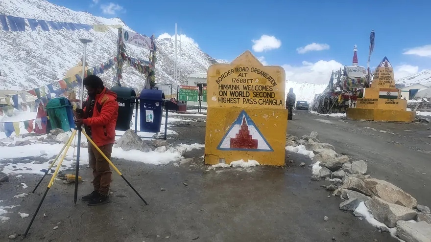
- High-altitude working conditions in Ladakh, where thin air, low temperature and short usable daylight limit field productivity and call for careful acclimatisation and crew planning
- A constrained seasonal weather window in the higher reaches, with passes and approach roads usable for only part of the year, requiring the programme to be sequenced by region rather than by convenience
- Remote and restricted access, with long approach drives, patchy communications and sample locations reachable only on foot from the nearest motorable point
- Limited existing survey control in the remote sectors, requiring reference stations to be established before dependent observation could begin
How did BTPL carry out the survey?
BTPL began by establishing a GNSS control framework, occupying reference stations tied to published control and observing static sessions to bring the work onto a consistent datum before any sample point was recorded. Ground truth locations were then observed by DGPS in differential mode, base and rover, with occupation times set according to baseline length and sky visibility at each site rather than by a fixed rule. At every point the crew recorded feature identity, land cover and site condition, supported by orientated photographs, so that the observation could be matched unambiguously to the corresponding block of pixels in the imagery. Regional deployment was sequenced against terrain and season, with the high-altitude sectors programmed for the accessible window and the valley and lower sectors covered around them; observations from all regions were then integrated into one continuous statewide dataset.
How was the data processed?
GNSS baselines were downloaded and post-processed against the occupied reference stations, with the resulting vectors adjusted and transformed into the datum and projection agreed for the project. Observed positions were then merged with the corresponding field attribute records and photographs to build a single ground truth database. The database was delivered in GIS-compatible form so that it could be overlaid directly on the satellite imagery for classification validation and positional assessment.
How was accuracy verified?
Control was verified through redundant baselines and closure checks before dependent observation was accepted, and reference station coordinates were re-checked over the course of the programme. Selected ground truth points were re-observed independently and the repeat observations compared against the originals as a field check on positional consistency. Attribute records were cross-verified against site photographs during office review, and any point where the recorded feature and the photographic evidence disagreed was flagged and resolved before submission.
What was delivered?
The Flood Control Department received a datum-consistent, independently observed ground reference dataset covering the whole of Jammu & Kashmir including Ladakh, against which satellite-derived mapping could be validated rather than accepted on interpretation alone. That verified base supports flood control planning, drainage and river-line assessment across the state, with the geospatial record traceable to observed ground coordinates.
Flood Control Department, J&K · via  Suhora Technologies Pvt Ltd
Deliverable extracts (orthomosaic, terrain, CAD) will be added once cleared for publication (client-sensitive information removed per BTPL policy).
Planning a Similar Project?
Share your location, scope and required deliverables — BTPL will propose the appropriate survey methodology.