
GCP Network with DGPS — 6 Stations
Geospatial · Multiple states
Project Overview
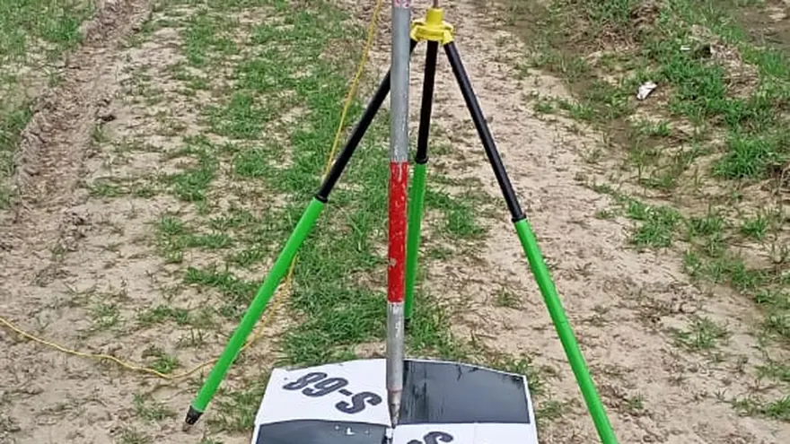
BTPL established six ground control stations to serve as the coordinated ground reference for a client's mapping programme. Each station was observed by static GNSS session and positioned differentially against published reference control — DGPS here meaning differential processing against that published control, not a local base and rover. The six marks stand in different states, so the set was brought onto a common datum through the reference framework all six were tied to. The client is not identified: the engagement is covered by a non-disclosure agreement, and the work is described here in terms of method, network and deliverable only.
What did the client require?
Positions measured in one region and positions measured in another can only be brought together if both are hung off marks whose coordinates are known on a defined datum and projection. A small number of properly observed, marked and fully described control stations provides that anchor. It realises the datum, gives a base from which dependent survey can be run, and provides an external reference against which mapped positions can later be checked. Where the stations serve mapping spread across several states, they have to be mutually consistent as well, so that data in one region sits in the same frame as data in another.
What made this project challenging?
- Six marks across multiple states, each one reached, reconnoitred, marked and observed as a deployment of its own.
- Distance to the nearest published reference control, which governs how long each static session has to run.
- Site selection constrained on several counts at once: sky visibility, ground stable enough to hold a mark, freedom from obstruction and reflective surfaces, the mark's safety from disturbance, and access for someone returning to it later.
- Permission to place and leave a ground mark, to be settled with whoever controls each site before observation could begin.
- Station descriptions that have to stand on their own, for a party recovering the mark who has never seen the site.
- Holding all six to one datum and one adjustment basis although they were occupied separately, so that the result is a single consistent set rather than six unrelated local coordinates.
How did BTPL carry out the survey?
Each site was reconnoitred before any observation was taken — sky visibility, ground stability, obstruction, the mark's safety and the practicality of getting back to it — and the ground mark was set once the position was settled. Observation was by static GNSS session, its length set by the baseline to the reference control being used and by the sky the site actually offered. Because the six marks stand in different states, none was fixed from a local base: each was processed differentially against published reference control, and it is that shared framework, not any vector between the marks, which puts the six in one frame. Every mark was occupied more than once, on separate sessions, so that no coordinate rests on a single occupation. At each station the description was compiled on site — mark type, access, sketch and the obstruction picture around the point.
How was the data processed?
Each station was a processing job of its own before anything was combined. Session data was downloaded and the baselines to the published reference stations were computed session by session, each solution examined on its own before it was allowed to contribute. Where a mark had been occupied more than once, the independent solutions were adjusted together by least squares to produce one coordinate for that station, the residuals of that adjustment being the direct measure of how far the repeat sessions agreed. The six station coordinates were then expressed in the datum and projection agreed for the deliverable. There are no direct vectors between the marks; what places them in a common frame is the published control all six were tied to. The adjustment report was written from these records — for each station, the sessions observed, the baselines computed, the reference stations held and the residuals obtained.
How was accuracy verified?
No coordinate was accepted from a single session. Every mark was occupied on separate occasions and the solutions from those occupations were compared before the station was adjusted; where the repeat sessions on a mark did not agree, the station was re-observed, and the disagreement was not averaged away. The published reference stations used for the ties were themselves checked for mutual consistency before any of them was held in processing. Station descriptions and sketches were checked against the adjusted positions in office review, so that each sheet unambiguously identifies the mark it belongs to and no two stations can be confused on recovery.
What was delivered?
Six control stations were handed over as one coordinated set: adjusted coordinates in the agreed datum and projection, a description sheet for each mark written for someone who has not been there, and an adjustment report setting out how each coordinate was derived and what it is held to. Positions measured from any of the six sit in the same frame as positions measured from the others, across the states covered, and the marks remain available as a base for dependent survey and as an external reference for checking mapped data.
Confidential — delivered under NDA
Deliverable extracts (orthomosaic, terrain, CAD) will be added once cleared for publication (client-sensitive information removed per BTPL policy).
Planning a Similar Project?
Share your location, scope and required deliverables — BTPL will propose the appropriate survey methodology.